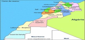
 The American search engine “Google Maps” has been pressed by hundreds of Moroccans to delete the demarcation line that separates Morocco from its Sahara on the map it currently displays.
In a petition circulated on social networks, Moroccans are asking the famous search engine to rectify the map which shows their country separated from its southern provinces, known as Western Sahara.
In the map displayed by Google, the Kingdom is divided into two parts by a line: the northern part is called “Morocco” and the southern part “Western Sahara,” a name inherited from the time of Spanish colonization.
For Moroccan petitioners, there is no “Western Sahara” on the ground but only a “Moroccan Sahara” and “no authority other than the Moroccan Government governs the southern provinces of the country.”
The petitioners argue that “Google is not a political organization which represents political views on world maps, but rather a search engine that must reflect the geographic realities of sovereign countries.”
This is exactly the case of Morocco, a country universally recognized as an independent and sovereign state by the international community and the United Nations, unlike the fanciful Sahrawi Republic (SADR) which was created in the 70s by the regimes of Algerian Houari Boumediene and Libyan Muammar Gaddafi at the time of the Cold War.
SADR exists only by its name that has been invented by the two regimes hostile to the Moroccan monarchy and its physical presence is limited to a tiny Algerian plot of land near the city of Tindouf.
Besides, SADR is recognized as a state only by very few African and Latin American countries, whose leaders at the time were lavishly thanked by Algerian petrodollars in exchange for the recognition of the ghostly Sahrawi Republic.
Those who launched the petition were vying 1,000 signatures, but in just a couple of days, the petition was signed by over 620 people, which heralds that the number 1,000 will be largely exceeded.
The big question now is how Google Maps webmaster will react to this request that seems logical as it seeks to have the map reflect the reality of things as they stand on the ground.